uni-app是什么?
uni-app 是一个使用 Vue.js 开发跨平台应用的前端框架,开发者编写一套代码,可编译到iOS、Android、H5、小程序等多个平台。
需求
位置定位,选择地图两点进行连线,实现步行导航功能。
核心代码
地图密钥和url配置。
var config = {
  key: '',
  url:'https://apis.map.qq.com/ws/direction/v1/walking/?'
}

module.exports = config;
uni-app请求封装。
import config from './config.js'
class HTTP {
	request(params) {
		if (!params.method) {
			params.method = 'GET'
		}
		if (!params.data) {
			params.data = '';
		}
		uni.request({
			url: config.url + params.url,
			method: params.method,
			data: params.data,
			dataType: 'json',
			success:function(res) {
				params.success(res)
			}
		});
	}
}
export {
	HTTP
}
布局实现。
<template>
	<view class="page-body">
		<view class="page-section page-section-gap">
			<map :id="myMap" style="width: 100%; height: 550rpx;" :latitude="data.latitude" :longitude="data.longitude" :markers="data.markers"
			 :includePoints="data.includePoints" :polyline="data.polyline" show-location></map>
		</view>
		<view class='content-container'>
			<view class='content'>
				<view class='post-container'>
					<view class='post' @tap='postData' v-if="data.plans.length == 2">
						<view>提交旅行线路</view>
					</view>
					<view class='post' @tap='clear' v-if="data.plans.length > 0">
						<view>重新添加</view>
					</view>
					<view class='post' @tap='chooseLocation' v-if="data.plans.length < 2">
						<view>添加旅行站点</view>
					</view>
				</view>

				<view class='item' v-for="(item,index) in data.steps" :key="index">
					<view>{{item.instruction}}</view>
				</view>
			</view>
		</view>
	</view>
</template>
核心逻辑代码。
var config = require('../../../libs/config.js');
	import {HTTP} from '../../../libs/http.js'
	let http = new HTTP;
	export default {
		data() {
			return {
				data: {
					steps: {},
					canPost: true,
					latitude: 0,
					longitude: 0,
					line_address: [],
					plans: [],
					travelDistance: 0,
					includePoints: [],
					markers: [],
					polyline: [{
						points: [],
						color: "#FF4500",
						width: 3,
						dottedLine: true,
						arrowLine: true
					}]
				}
			}
		},
		onLoad() {
			let _this = this;
			uni.getLocation({
				type: 'wgs84',
				success: function(res) {
					var latitude = res.latitude
					var longitude = res.longitude
					let includePoints = _this.data.includePoints;
					includePoints.push({
						longitude: longitude,
						latitude: latitude
					})
					_this.latitude = latitude,
						_this.longitude = longitude
					_this.includePoints = includePoints
				}
			})
		},
		onReady() {
			uni.createMapContext("myMap");
		},
		methods: {
			chooseLocation: function() {
				let _this = this;
				uni.chooseLocation({
					success: function(res) {
						let plans = _this.data.plans;
						let plan = {
							id: plans.length,
							name: res.name,
							address: res.address,
							latitude: res.latitude,
							longitude: res.longitude
						};
						_this.data.line_address.push({
							latitude: res.latitude,
							longitude: res.longitude
						})
						plans.unshift(plan);
						_this.plans = plans


						//画线
						let polyline = _this.data.polyline;
						let points = polyline[0].points;
						points.push({
							longitude: res.longitude,
							latitude: res.latitude
						})
						polyline[0].points = points;
						_this.polyline = polyline

						//视野缩放
						let includePoints = _this.data.includePoints;
						includePoints.push({
							longitude: res.longitude,
							latitude: res.latitude
						})

						//标记坐标点
						let markers = _this.data.markers;
						markers.push({
							id: markers.length - 1,
							latitude: res.latitude,
							longitude: res.longitude,
							width: 50,
							height: 50,
							label: {
								content: res.name,
								fontSize: 8,
								bgColor: "#FF6347",
								color: "#FFFFFF",
								padding: 5,
								borderRadius: 10
							}
						});

						_this.data.polyline = polyline,
							_this.data.includePoints = includePoints,
							_this.data.markers = markers
					},
					fail: function(err) {
						console.log(err)
					},
					complete: function(res) {}
				})
			},
			/**
			 * 提交旅行计划
			 */
			postData: function() {
				let _this = this;
				uni.showModal({
					title: '温馨提示',
					content: '你确定要提交旅游线路吗?',
					success: function(res) {
						if (res.confirm) {
							_this.getLine()
						} else if (res.cancel) {
							console.log('用户点击取消')
						}
					}
				})
			},
			/**
			 * 用户点击取消
			 */
			clear: function() {
				let _this = this;
				uni.showModal({
					title: '温馨提示',
					content: '你确定要重新制定旅游线路吗?',
					success: function(res) {
						if (res.confirm) {
							_this.data = {
								canPost: true,
								latitude: 0,
								longitude: 0,
								plans: [],
								line_address: [],
								travelDistance: 0,
								includePoints: [],
								markers: [],
								polyline: [{
									points: [],
									color: "#FF4500",
									width: 3,
									dottedLine: true,
									arrowLine: true
								}]
							}
						} else if (res.cancel) {
							console.log('用户点击取消')
						}
					}
				})
			},
            /**
            *获取步行导航
            */
			getLine: function() {
				var _this = this
				let url = 'from=' + _this.data.line_address[0].latitude + ',' +
					_this.data.line_address[0].longitude + '&to=' + _this.data.line_address[1].latitude + ',' + _this.data.line_address[
						1].longitude + '&key=' + config.key;
				http.request({
					url: url,
					success:  function(res){
						_this.data.steps = res.data.result.routes[0].steps
					}
				})
			}
		}
	}
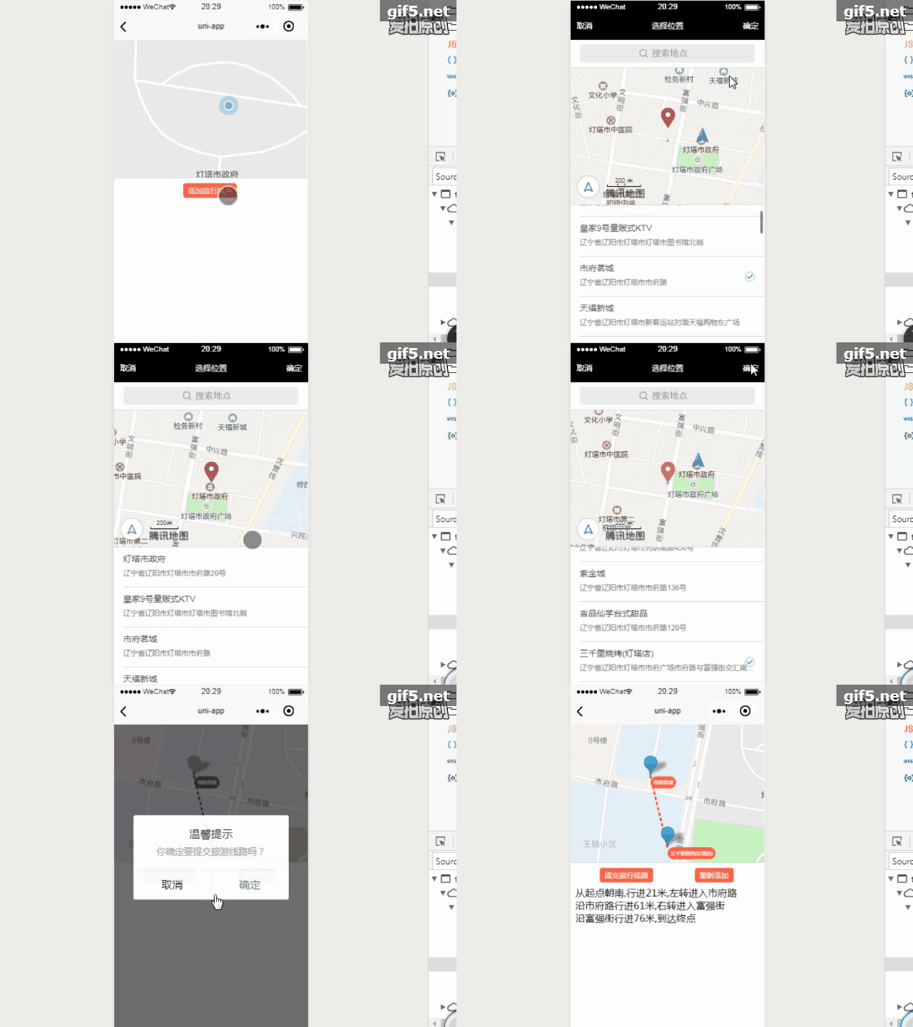
效果展示。
点击查看更多内容
1人点赞
评论
共同学习,写下你的评论
评论加载中...
作者其他优质文章
正在加载中
感谢您的支持,我会继续努力的~
扫码打赏,你说多少就多少
赞赏金额会直接到老师账户
支付方式
打开微信扫一扫,即可进行扫码打赏哦


